Hidden Agenda
~~ PART THREE ~~
![]()
Page Links
![]() What to Expect From a Psychic Reader
What to Expect From a Psychic Reader
![]() Personal PowerPoint Presentations
Personal PowerPoint Presentations
![]() Proof Positive, Metaphysical Wisdom
Proof Positive, Metaphysical Wisdom
![]() Proof Positive: Book Introduction
Proof Positive: Book Introduction
![]() FAQ for Developing Psychics & Mediums
FAQ for Developing Psychics & Mediums
![]() Grief Recovery / Experiencing Loss
Grief Recovery / Experiencing Loss
![]() Working with Psychic Medium, John Edward
Working with Psychic Medium, John Edward
![]() On the Music Scene with Strange Brew!
On the Music Scene with Strange Brew!
![]() 2012 - And the End of the Mayan Calendar
2012 - And the End of the Mayan Calendar
![]()
Hidden Agenda
~~ PART THREE ~~
Part 3 of 3
This section deals with
image tampering and hidden communication.
![]()
IMAGE TAMPERING


Wings No Wings
SAME PHOTO
IMAGE TAMPERING & NASA COVER-UP
As you can see in the above image, it's very easy to change or enhance features in a photograph. There are literally hundreds of thousands of photos that NASA has enhanced in a variety of ways - which also includes tampering with images using various graphic programs like Photoshop - for the purpose of hiding things they don't want us to see. There is no question about the fact that they do this because it's fairly easy to see sections on many images that are smudged - or that have sections with 'copy and paste' applications added; you simply have to zoom in and look. I actually show many examples of this in two of my lectures... one about the Moon - and one about Mars.
Joe Skipper's web site has been up for many years and he has a nice collection of images (mostly photos of Mars and the Moon) - which have all been taken from the NASA / JPL / MSSS web site (MSSS is also known as Malin Space Science Systems)... and more recently, some of the more interesting - and clearer - images also come from the ESA (European Space Agency), Google Mars and Google Moon. Many images show tampering on a wide scale.
Joe has also maintained from day one that there was 'water on Mars' - because he was able to see the evidence for it - and then lo and behold, years later... NASA finally made that big anouncement that 'Mars had oceans at one time... and there is still water there' [below ground and at the polar ice caps]. You can look at his web site here - but this is only a small glimpse of images like this.
But you don't have to take my word for the
fact that 'NASA tampers with photos'...
I'm going to show you - step by step - how you can see an image that was tampered with - if you follow a few simple instructions. I'm providing you with the links to an image on the web... so I encourage you to copy that image, save it to your hard drive and try this for yourself; all you need in your computer is any type of program that can lighten and sharpen photos - and also enlarge them... because it's THAT easy.
Here's the Image
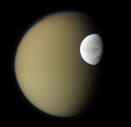
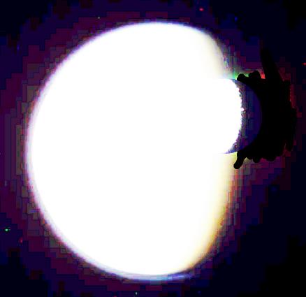
This photo is right on one of NASA's sites, called: Astronomy Picture of the Day. When you click on the above link, you will see all the image thumbnails (including the one I'm featuring) posted for April of 2010. Image number 20 [below] is a picture taken from the Cassini spacecraft of Saturn's moons, Dione and Titan. Now I'm going to show you a sequence of enhanced images of this photo where you will see that someone took a black marker and blackened 'something' out - something that they did NOT want us to see.
Ready?
Okay, look CLOSELY at this photo of Titan and Dione below... This is copied from the web link above.
This is a reduced size of the original image
(so that it would fit on this page).
However, I have not yet made any other
enhancements to this image.
NOW LET'S PLAY...
Here (above) I've lightened it a little bit; look at the right side edges of Dione (the small moon); you can see some 'hard edges' there, around the crescent... (if you're on a computer, you might need to tilt your screen slightly toward you - to see the contrast).
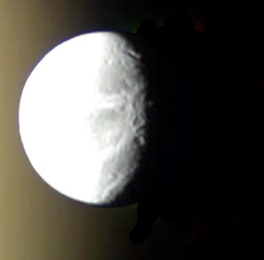
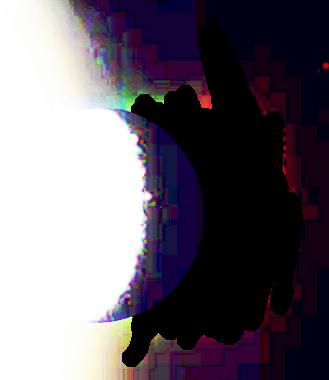
Now let's - ZOOM IN - on the small moon... but I have not yet enhanced it any further. We're just taking a closer look at the smaller, brighter moon.
BOTH MOONS
This time, I highly enhanced it - using light and contrast. Since space is not really 'true black', it will show up with some color - within the light reflected from the moon. What IS showing up true black are the black marks that were added to hide whatever is reflecting light behind the small moon. And whatever that is, it is HUGE and is emitting quite a bit of light, in both the red and green spectrum.
NOTE: If you were to trace the outline of the large moon in it's entirety, the red and green light appears to be coming from the SURFACE of that moon - or is hovering directly above it.
For some size comparisons, here's the Wikopedia page on 'the size of Dione' (that's the smaller moon above - in front of Titan): http://en.wikipedia.org/wiki/Dione_(moon)
So let's - ZOOM IN AGAIN - only on the smaller moon.
CLOSE UP OF DIONE
(the small moon)
In this close-up of Dione, you can see that whatever this thing is behind that smaller moon; the light itself is at least as large as the small moon, Dione. By now, you have hopefully pulled this image off the web site yourself - to play with it in your own computer.
So do you still think that NASA tells us the truth?
This is just one of THOUSANDS of photos like this - that show tampering. And I've seen quite a few of them; they're actually not that difficult to find.
But this one is especially interesting - because you can check it out for yourself. It's one of the easier photos that anyone can access.
NOTE: I don't know 'who' does their touch-up work, but they are total amatures. Either that, or they just don't care if we find the tampering marks...
Meanwhile, when NASA was questioned about this photo, they said that they 'just enhanced and corrected an imaging problem'; here's their response.
HIDDEN COMMUNICATION
What does:
NASA / THE PACIFIC OCEAN / MARS / X MARKS THE SPOT
Have in common???
When I first came across this information, I had an immediate 'gut reaction' that actually made me feel physically ill. When I show you what I found, your first impression will probably be the same as everyone else's (including mine) - that what you're seeing looks a whole lot like a target - or a strike zone on the Earth.
But it's not...
I think that have actually figured out what this is - and based on the searches that I've done, I might be the only one who has.
This is actually a perfect example of how that 95% of crap posted on YouTube and all the MISINFORMATION that is floating around on the web influences people in such a way that can be very scary. At the same time, it does call into question: WHY NASA created this in the first place - and exactly WHAT does it mean?
I used to encourage everyone to try accessing this on their own... except now, Google has blocked it - and no longer allows the map files to be downloaded from the Google search engine. I'm sure that the files still exist, but they no longer show you how to access them.
But I can still walk you through the process - and show you what it looked like.
Someone on a German web site saved the image, before Google took down the files!So here's how it worked (before Google BLOCKED it...) I simply went to the Google search engine at: www.google.com and typed in the following:
11133.kml
The very first link that came up was entitled:
11133.kml - byss
That format is a KML file... which indicates
that it's a map.
A few years back, that link listed the following web address in the discription: byss.arc.nasa.gov/maps/mars/visible_kml/111/11133.kml
However, even though that link is no longer available,
I wanted you to see it, because the way that link reads is very important - which is the only reason why I left it here.
As you can see from the original web address, it was indeed a NASA site; you can see 'nasa.gov' in the address... and you can also see 'mars' in the address. And the number at the end: 11133 - represents 'a designation site'.
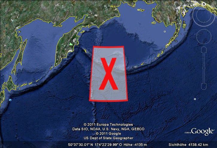
HERE'S THE MAP THAT USED TO OPEN
WHEN YOU CLICKED ON THAT LINK
Google Earth would fly you to this location
and the X would open on the screen.
And to be honest, it was just a little bit creepy.
So what you see in the above image is the north Pacific Ocean... and to the right is Alaska and the Aleutian Islands - and to the left, is Russia.
BUT WHY IS THIS X THERE?
Now I'll tell you what I think this is - and you won't find this explanation anywhere else - because no one else has connected the dots in quite this way.
The clue was in the word 'mars' in the address bar. It doesn't stand for the planet Mars. It's an acronym. It stands for: Military Auxiliary Radio System – and this is what they use for ‘emergency communications’ - in survival situations. This is a Department of Defense sponsored program that uses Ham Radio Operators for the purpose of emergency communications. Take a look at this link:
http://navymars.org/national/mission.htm
But it STILL begs the question: Why would NASA need this - or be involved in this type of communications network, for that matter?
But there's more...
I discovered that if you played around with that KML address - and change the last two digits of that number: 11133 (going backward: 32, 31, 30... and forward: 34, 35, 36, etc.) more Red X's would pop up on your Google Earth Map! I was able to find a wide-ranging grid covering almost the entire North Pacific [forming a triangle] all the way up to the North Pole.
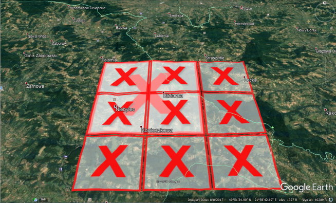
But I realized later... that these X marks the Spot grids are actually all over the Earth. Here's another sample that I found on another web site. When I clicked on the link, Google Earth flew me to this location in Poland!
NOTE: I first disclosed this info in January 2012.
But I have not seen anyone else address this from a communications standpoint.
Now, if you search the internet, you will also find that this info ties into a comet named Elenin that was supposed to arrive [as a near Earth object] in 2011... so many people were concerned that this might indeed be showing a 'strike zone'. However, 2011 came and went and so did the comet. And I haven't heard any updates about this on the web; and the existing links regarding this comet are all old.
So there is an entire 'emergency communications network' in place with specified [numbered] grids on the map... And I suspect that these grids are global - and cover every inch of the Earth.
BUT WHY?
Why is this built into the Google Earth Platform?
And what is the government anticipating...
that we would need to use THIS type
of primative network - instead of the advanced communications technology that we currently have?
Are they worried that someone
- or something -
will take out our communication satellites?
And why is NASA involved in this?

SYNOPSIS / WITHHOLDING INFORMATION
So what might all of this
have to do with UFO's, NASA, 2012...
Or our new Space Force?
Well... it's not exactly a NEW space force. We've had a space force for nearly seventy years. Where do you think all of those TRILLIONS of missing dollars went?
What IS new is the disclosure of this, which will now be slowly rolled out.
But I digress...
If there are 'cosmic changes' taking place in our solar sytem,
then NASA would be involved - at a very high level.However after what I've just shared with you, do you REALLY trust them to tell you the truth?
I certainly don't.
NASA
Nondisclosure And Suppression Administration
- more affectionately known as -
Never A Straight Answer
To be continued...
Please check back and I will continue to add more information as it comes to light...
In the meantime... Thanks for visiting!
Doreen Molloy

![]()


![]()